기사입력 2016.03.21 06:37


It is pointed out that, for wearable market to overcome ‘Chasm’ and succeed in popularization, solving compatibility issue and establishment of standardization is urgently required. Viewing that “smart wearable market still has many unsolved issues and discussion of its standardization is just at its beginning stage,” Dr. Chun, Jong-Hong of ETRI said that “aggressive standardization strategy and response is demanded and we should approach the standardization from the user’s point of view.”
2016-03-10 오후 9:13:43by

Cypress, renowned for its SRAM and PSoC processor lineups, was merged with Spansion, which is strong in memories and automotive MCUs, in early 2015. We met Hyung-Joon Kim and Hwan-Kook Cho, managers of Cypress Semiconductor, to glimpse into the future of the company’s MCUs.
2016-03-21 오전 6:12:32by
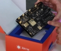
Samsung Electronics, which officially announced ARTIK, its IoT platform, last month, had its product demonstration for engineers in the small and medium companies on March 3.
2016-03-21 오전 6:27:26by


.png)
.png)
[열린보도원칙] 당 매체는 독자와 취재원 등 뉴스이용자의 권리 보장을 위해 반론이나 정정보도, 추후보도를 요청할 수 있는 창구를 열어두고 있음을 알려드립니다.
고충처리인 장은성 070-4699-5321 , news@e4ds.com


